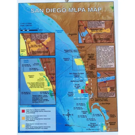
San Diego MLPA Map
81/2″ x 11″ laminated two-sided map showing areas affected by MLPA closures. Detailed maps help you identify where to fish and which zones are designated as State Marine Reserve (SMR), State Marine Conservation Area (SMCA no take), or State Marine Conservation Area (SMCA take).
Stay safe and avoid restricted areas with this map. Includes all GPS coordinates for precise location reference.
| Map Features | Details |
|---|---|
| Size | 8.5″ x 11″ |
| Material | Laminated |
| Side Count | Two-sided |
| Content | MLPA closures, SMR, SMCA no take, SMCA take zones, GPS coordinates |
FAQ
Are the GPS coordinates accurate for real-time navigation?
The GPS coordinates provided are accurate and based on official MLPA designations. They are intended for reference and planning purposes.
Can this map be used for both recreational and commercial fishing?
Yes, this map is designed for both recreational and commercial fishing to help identify permitted and restricted zones.
Is the map updated regularly?
Please contact customer service for information on the update frequency of this map.


Bella Lee –
This map is very clear and easy to read. I use it regularly to plan my fishing trips and avoid restricted zones. The GPS coordinates help me locate areas accurately. A must-have for any fisher in San Diego.
Joanne Mitchell –
The laminated quality makes it durable. I’ve used it for several trips and it hasn’t faded or torn. The two-sided design is helpful for quick reference during fishing.
Joseph Skinner –
I was worried about accidentally fishing in a no-take zone. This map gave me confidence. The detailed markings and GPS points made it easy to navigate safely.