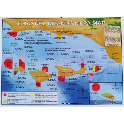
Channel Islands MLPA Map
81/2″ x 11″ laminated two-sided map showing areas affected by MLPA closures. Detailed maps help you know where to fish and which area is affected by a State Marine Reserve (SMR), State Marine Conservation Area (SMCA no take), or if it’s a State Marine Conservation Area (SMCA take).
Keep yourself out of trouble with these maps. Contains all GPS coordinates.
| Map Features | Details |
|---|---|
| Size | 8.5″ x 11″ |
| Material | Laminated |
| Side Count | Two-sided |
| Content | GPS coordinates, SMR, SMCA no take, SMCA take zones |
FAQ
Are the GPS coordinates on the map accurate and up to date?
The map includes GPS coordinates as provided in official MLPA documentation. Accuracy is based on published data and may vary slightly due to mapping sources.
Can I use this map for fishing in all California coastal areas?
This map specifically covers the Channel Islands MLPA areas. It is not applicable to other coastal regions.
Is the map waterproof or durable for outdoor use?
The map is laminated, which provides water resistance and durability for outdoor use.
Harry Terry –
This map is very helpful when planning fishing trips. The GPS coordinates make it easy to locate restricted zones. I use it regularly and it’s saved me from accidentally entering a no-take area.
Jake McLean –
Clear layout and easy to read. The two-sided design is useful for checking both sides of the islands. I appreciate the inclusion of GPS points for precise navigation.
Eric Davies –
Great tool for staying compliant with marine closures. The laminated quality holds up well even when exposed to sun and rain during outdoor trips.